
The end of war in Sri Lanka, captured for posterity by Google Earth

Groundview
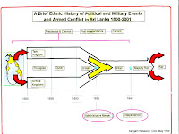
When in early 2009, UNOSAT released satellite imagery of what later turned out to be the final weeks of Sri Lanka’s 27-year old war with the LTTE, the images were met with vehement Government condemnation, and counter-analysis by the Ministry of Defence. During this heady, hellish time, the subject of The Cage: The Fight for Sri Lankan & The Last Days of the Tamil Tigers by former UN spokesman Gordon Weiss and the recently released Still Counting the Dead: Survivors of Sri Lanka’s Hidden War by the former BBC correspondent Frances Harrison, while the President assured Sri Lankans and the world that heavy weapons weren’t being used, the satellite images from UNOSAT added to the confusion, showing clear and widespread indications of heavy shelling. The question then became when the shelling occurred. From the report by the UN Panel of Experts, appointed by the UN Secretary General to the Lessons Learnt and Reconciliation Commission’s Final Report, the trading of allegations and counter-allegations over the use of heavy weapons and the deliberate targeting of civilians continues apace. It is a heated, deadly serious debate.
When, for obvious reasons, during the UN HRC sessions in March this year, a web news report titled Is Google Earth Hiding Sri Lanka’s Ghosts? was published, the attention of Groundviewswas directed towards the existence, on Google Maps and Google Earth (which largely share common geo-spatial tiles and database), of imagery focussing on the North East of Sri Lanka, taken from the first quarter of 2009. The original story was largely conspiratorial – alleging that Google was somehow, through careful blurring of ground truths in their geo-spatial database, aiding the Sri Lankan government escape war crimes charges. The real story was thus missed – the existence of this imagery, which no one in Sri Lanka including the government and no international human rights organisation we know of, have studied or flagged in detail.
This is a first and non-exhaustive crack at exploring this vast imagery. We sincerely hope it contributes to a larger, crowdsourced investigation into what this imagery can reveal about those final brutal weeks of war. Groundviews is guided by two key reports, both published by UNOSAT.
- Satellite Atlas: Civilian Safety Zone (CSZ) Mulattivu District, Sri Lanka, released 23 March 2009
- Updated Analysis Report (19 April 2009) Satellite-Detected Damages and IDP Shelter Movement in CSZ, Mullativu District, Sri Lanka (the original location on UNOSAT servers doesn’t seem to work anymore, so this is a copy of the PDF we’ve uploaded anew)
Usually, satellite imagery is inaccessible for crowdsourced analysis because of one key factor – money. A single tile (say a frame of 1km by 1km) can cost thousands of dollars to acquire, making satellite image acquisition theoretically a commercial possibility, but in fact, impossible for any Human Rights organisation in Sri Lanka to even imagine undertaking. At scale and over time, this is not something even the largest International Human Rights organisations can afford.
Google Maps / Google Earth offer, for our purposes, two advantages over the acquisition of commercial satellite imagery, the cost saving aside. One, the availability of good enough satellite imagery to work with. The other, historical imagery, from 2009, to compare and contrast specific geographical areas and any visible changes. There is historical imagery from as far back as 2005 and up to the end of 2011, but for the purposes of this study, imagery dated 3/16/2009, 5/24/2009, 6/15/2009 and 9/8/2009, which show the most amount of detail on shelling and the locations of the so-called Civilian Safety Zones (CSZ), have been used extensively. A final advantage of crowdsourcing this kind of work is that it is, in a sense, open data. Anyone, from anywhere, for free, can confirm or contest a sighting of something interesting, and flag other points of interest.
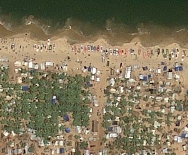
What Google Maps and Earth does NOT enable one to do, given (1) the quality of some of the historical imagery (which sometimes features extensive cloud cover of vast regions) and (2) the large gaps between the available historical imagery (mid March, late May, after the official end of the war and killing of the LTTE’s leader, then mid-June and early August) is any robust analysis on when shelling in a specific region took place, and importantly, by whom. Resolution matters, and allows for certain kinds of analysis and spotting. While it is possible, for example, to discern the effects of shelling,
Click here for larger image.
at almost the same zoom level (the maximum possible without serious pixellation / image corruption), it is virtually impossible to discern with any accuracy what individuals or groups of IDPs were doing on the beachfront of CSZ on 3/16/2009.

Click here for larger image.
Ultimately, what Google Maps / Earth have recorded, and quite clearly, is the sheer scale and extent of the destruction and human displacement in Sri Lanka during the final phase of the war, between March and May 2009. Plotted on a map, seeing this is fundamentally different to reading about the same information in a static report. In all the examples below, we have extrapolated from the UNOSAT report lat/long coordinates you can copy and paste into Google Earth to quickly zoom into an area, and then use the time slider to go back to available imagery from previous years around that area.
For general orientation, the sliver of land sandwiched by lagoon and sea highlighted in grey below, between Puttumattalan in the North and Mullaitivu in the South, is the area of study.