
Sri Lanka: Using Google Earth as a storytelling tool

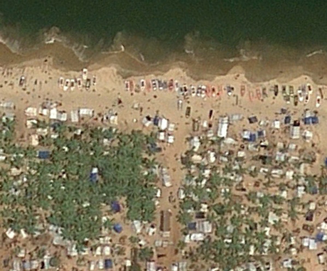 The old adage says that a 'picture tells a thousand words'. And by using just two satellite images from Google Earth, taken two months apart, a citizen journalist has been able to tell the story of the end of Sri Lanka's 25-year civil war.
Back in November 2012, Sanjana Hattotuwa, founding editor of Groundviews, a site dedicated to 'journalism for citizens', realised that by using the Google Earth time slider, a tool which shows satellite imagery taken on different dates, he could see the presence and subsequent disappearance of refugee camps. The images show a littoral sliver of land between the sea and a lagoon in the north-east of Sri Lanka where displaced people were living in camps.
re four occasions where the war ending is catalogued". (The audio interview with Hattotuwa is here.)
"The intention was not actually to ascertain culpability," Hattotuwa said in the interview. "It is impossible to ascertain who shot what and when, but it is very clear from the imagery that it's a scorched earth policy, you can see pock marks all over the place."
Image: Google Earth
Hattotuwa addded: "It is an interesting use case of Google Earth to flesh out inconvenient truths about a country's recent past."
Sri Lanka Using Google Earth as a Storytelling Tool by nelvely